From our daily mail, the content of the GSDI Newsletter just received:
"From June 15th through June 19th the GSDI 11 World Conference in Rotterdam will be the beating geospatial heart of the world! GSDI, INSPIRE (EU) and Geonovum/RGI (NL) are organizing in synergy with each other a high-quality integrated conference with top national and international speakers.
This newsletter will inform you on a regular basis about latest breaking news and details of the conference.
CALL FOR PAPERS A BIG SUCCESS
The Call for Papers for the GSDI 11 World Conference attracted close to 350 abstracts. These abstracts cover a wide selection of inspiring geo-related themes drawn from all over the world. The program committee is actively selecting the most innovative and appealing contributions for oral presentation and for the poster program. The conference provides authors an opportunity to present their work in June 2009 in Rotterdam to an international audience. The selection of abstracts for GSDI 11 will be announced on or about February 1.
PLATINUM SPONSORS CONTINUE TO JOIN
With pride we are pleased to announce that Cyclomedia has joined ESRI and EuroGeographics as Platinum Sponsors for the conference.
CEO Paul Bosman states:
"CycloMedia recognizes that GSDI is a vast platform to discuss the challenges that different organizations face at the (inter)national, public and private level. It is a pleasure to have the Netherlands act as host country this time and I am proud that CycloMedia can deliver a contribution to this worldwide conference".
ESRI spokesman Frank Holsmuller clarifies:
"ESRI recognizes the GSDI conference as THE event to meet and inform the key players in the field of geo information. The GSDI-11 event promises to become extra interesting because it will take place close to the heart of the INSPIRE program."
EuroGeographics, the association for cadastral organizations in more than 40 European countries, is quite involved as well. The executive director, Dave Lovell, says enthusiastically:
"We are building bridges between our members and the many communities of users who rely on their authoritative information. We are pleased to have the opportunity to improve and enrich these inter-connections in the wider community of this conference and look forward to using the GSDI 11 World Conference to further expand the use of spatial data infrastructures for the benefit of all."
WANT TO KNOW MORE?
Can't wait for the next newsletter? Then visit http://www.gsdi.org/gsdi11. You can now use your credit card to register on the web and please check out the early bird registration.
See you in Rotterdam!
--
****************************
If a friend or colleague would like to sign up for the GSDI News List,
direct them to http://www.gsdi.org/"
Saturday, December 20, 2008
Tuesday, December 16, 2008

Friday, December 12, 2008
ePSIplus-Net survey on Pricing/Charging in the PSI-reuse context
This morning HUNAGI circulated a survey questionnaire compiled by ePSIplus anchor Chris Corbin to the members and partners of the Hungarian Spatial Data Interest Community to use the replies to formulate a HUNAGI contribution to ePSIplus Thematic Network. The replies will be forwarded to ePSIplusNet before its last Thematic Workshop held in Paris but it will be used also in the cost/benefit analysis and comparative pricing model assessment to be prepared for the MoEW responsible for INSPIRE in Hungary.
Thursday, December 11, 2008
GRASS course and CASCADOSS Project Workshop in Szeged

Szeged University
January 27-30, 2009
Preliminary program and link to the registration site: http://infotrade.hu/cascadoss/program.html
For more information please write to cascadoss@gmail.com
Tuesday, December 09, 2008


Thursday, December 04, 2008
Climatic changes and Hungary - Conference on the scientific achievements
Building of the Hungarian Academy of Sciences. Image: HUNAGI Visuals resource, 2008
Climatic change: Environment - Risk and the Society

Climatic change: Environment - Risk and the Society
The conference hosted by the Hungarian Academy of Sciences attracted the scientific and R+D communities. Some representatives of HUNAGI member institutions were among the presenters and the participants including the Research Institute of the Soil Sciences and Agrochemistry, Hungarian Institute of Geology, Hungarian Geographical Society, Debrecen University, Institute of Mathematics and Informatics of the Corvinus University at Budapest
Saturday, November 29, 2008
EUROGI EMM in Gothenburg focused on EU SDI-related projects


The Extended EUROGI Members' Meeting attracted participants from many European countries including a 3-member HUNAGI delegation from Hungary. also the industry was well represented by regional representatives of the leading global GI companies having anchor in Europe
Images: HUNAGI Visuals resource, 2008
Thursday, November 27, 2008
Prof Chen Shupeng passed away
Father of the Chinese GI/RS passed away o 25th November 2008. The message was sent by Prof Wang Changlin, Secretary of the International Society of Digital Earth. For more details please visit http://hunagi56.blogspot.com. Condolences were sent both ISDE Secretariat and his beloved family on behalf of the Hungarian Geospatial Data Interest Community this morning.
Wednesday, November 19, 2008
Representative of UNOOSA/SPIDER met with UNSDI HUCO Stakeholder

Lóránt Czárán (r) of UN OOSA/SPIDER met with Chief Advisor of the Hungarian Meteorological Service, delegate of Hungary to GEO Prof. Zoltán Dunkel (m) and the Secretary General of HUNAGI (member of the GSDI delegation to GEO) Gábor Remetey-Fülöpp (l) during the GEO Plenary held in the Romanian Parliament this morning.
Some snapshots of the Romanian Parliament building, venue of the GEO V Plenary.
Digital Earth-UNGIWG/UNOOSA-GSDI high level informal talk in Bucharest

Prof. Guo Huadong (ISDE), Lóránt Czárán (UNOOSA) and Prof. Bas Kok (GSDI) met for an informal talk at the break of the GEO Vth Plenary Meeting held in Bucharest this afternoon. Image: HUNAGI Visuals resource, 2008
GEOSS GCI and Registration Process

Ivan B. DeLoatch, Director of the US Federal Geographical Data Committe at USGS gave an in-depth overview on the GEOSS Common Infrastructure (GCI) and highlighted the process to register new services.
GSDI Statement at the GEO announced by President Prof Bas Kok today

GSDI Statement for the GEO Plenary, November 19-20, 2008 as announced by Prof. Bas Kok, President of the Global Spatial Data Infrastructure Association this morning.
"The Global Spatial Data Infrastructure Association (GSDI) is pleased to engage and contribute as a Participating Organization to the Group on Earth Observation and, in particular, to the realization of the Global Earth Observation System of Systems, GEOSS. Currently, more than 80 countries are developing spatial data infrastructures that provide network-enabled access to data, maps, and base imagery, using a common set of standards for metadata, services, and data.. These standards, as well as best practices, are now registered in GEOSS and are critical to its function.
There are three opportunities of collaboration with GEO that the GSDI Association wishes to highlight.
First, countries developing SDIs are being encouraged to register their systems, services, and standards with GEOSS. The GEOSS registries then provide a resource directory for both GEO and GSDI communities.
Second, from an architectural point of view, the GSDI and GEOSS approaches are closely harmonized. To support the architectural approach, the GSDI community has developed a "SDI Cookbook" as a guidance that we offer as resource, and it includes a baseline of SDI-related standards promoting interoperability.
And third, in general, data sharing principles and practices in the SDI community are generally more open than those currently in the earth observation community, but we welcome the implementation of more open data sharing principles being considered within GEO -- principles that should be consistently applied to all earth observations and spatial data.
The GSDI Association will continue to work together with GEO at a technical level, however, we would like to explore the possibility of creating a more strategic alliance. The Association would like to amplify the success of both organizations and seek a similar level of ministerial and executive visibility and support of contributed systems, products, and services through coordinated efforts.
In closing, the next GSDI Conference, GSDI-11, will be held in Rotterdam, Netherlands, the 15th-19th of June 2009. We are proposing a track of presentations on GEO/GEOSS-related activities to demonstrate our common interest and synergies. We are pleased to acknowledge the confirmation of a keynote presentation by the Director of the GEO Secretariat, Dr. Jose Achache. The Association members welcome your attendance and participation in this upcoming biennial international conference. Thank you."
Monday, November 17, 2008
Vth GEO Plenary in Bucharest
GROUP ON EARTH OBSERVATIONS
For use of the media only; not an official document.
PRESS RELEASE
Bucharest conference to strengthenenvironmental monitoring of planet Earth Global Earth Observation System of Systems (GEOSS) will save lives, improve resource management, and track humanity’s impact on the environment Bucharest, 14 November 2008 – Some 300 officials from the Group on Earth Observations’ member governments and organizations are meeting here on 19 and 20 November to plan the next three-year phase in the construction of a new global monitoring network that will support science-based decision-making about environmental risks and opportunities.
The Global Earth Observation System of Systems, or GEOSS, is linking together the world’s diverse monitoring networks, instruments, data bases, models and other decision-support tools into one fully coordinated “system of systems”.
By integrating data from ocean buoys, weather stations, satellites, seismic monitors and innumerable other
technologies, GEOSS will empower decision-makers to address climate change, biodiversity loss, water
shortages, disease epidemics, natural disasters and other critical global challenges. “The satellites, ground sensors and other building blocks for measuring environmental parameters are now in place. They only need to be linked to one another to form a comprehensive ‘system of systems’, or GEOSS, that will track carbon stocks in our forests, forecast variations in food and water supplies, identify vulnerabilities to climate change and disease and provide other integrated and targeted information we need to address the world’s most pressing problems,” said GEO Director José Achache.
In Bucharest, the GEO annual plenary (GEO-V) aims to finalize and adopt the 2009-2011 work plan for constructing GEOSS. GEO members are contributing to this voluntary global project by expanding and interlinking their respective observation systems. The proposed new work plan aims to take GEOSS from its start-up phase to the implementation phase that will actually put the components of GEOSS into place. Key elements of the draft work plan include:
• Establishing the GEO Portal. The “GEOSS Common Infrastructure” consists of web-based portals;
clearinghouses for searching data, information and services; and registries containing information about
GEOSS. It will provide a “one-stop shopping” portal to help the users of Earth observations to access
and search for information more easily. The GEO community is currently evaluating the various
elements that have been put into place with the aim of finalizing the arrangements in 2009.
• Promoting free access to data. GEOSS can only succeed if Earth observation data is widely and freely
available to all interested users. GEO is building an international consensus that will make it possible to
adopt the GEOSS Data Sharing Principles at a Ministerial Summit in 2010.
• Advancing the GEO Biodiversity Observation Network. The complexity of biological diversity, and the
highly distributed nature of the systems and organizations that monitor it, make establishing the
“biodiversity arm” of GEOSS a particular challenge. The Bucharest meeting will be presented with an
implementation plan for making a biodiversity observation network (GEO BON) a reality.
• Building a system for monitoring forest carbon. GEO is responding to growing international interest in
tracking carbon flows by elaborating a plan for interlinking an array of existing and planned forest
carbon monitoring instruments and tools. The plenary meeting will be asked to give this plan the goahead.
The Group on Earth Observations was established in 2005 after the World Summit on Sustainable
Development (WSSD), the Group of Eight leading industrialized countries (G8) and three ministerial Earth
Observation Summits all called for improving existing observation systems. Its membership now includes 75
governments and the European Commission; 51 “participating organizations” also contribute to its work.
GEO is building the Global Earth Observation System of Systems on the basis of a 10-Year Implementation
Plan, which runs through the year 2015. GEOSS addresses nine priorities of critical importance to the future of
the human race: it will help countries to protect themselves against natural and human-induced disasters,
understand the environmental sources of health hazards, manage energy resources, respond to climate change
and its impacts, safeguard freshwater resources, improve weather forecasts, manage ecosystems, promote
sustainable agriculture, and conserve biodiversity.
Note to journalists: Journalists are invited to two back-to-back press conferences that will take place on
Wednesday, 19 November, in the Palace of the Parliament. The Government of Romania will brief in
Romanian at 12h30 and the GEO Co-Chairs will brief in English at 13h.
For more information, please see www.earthobservations.org or contact Anca Racheru of the Romanian Space Agency for accreditation information at +40 21 316 8722 or Michael Williams of the GEO Secretariat from 17-22 November at +41 79
572 9628 or mwilliams@geosec.org and from 24 November at +41 22 730 8293.
Saturday, November 15, 2008
Some important news on UNGIWG and UNSDI
UN Complex at the Vienna International Centre. Image: HUNAGI Visuals resource, 2008
Resolution on the United Nations Spatial Data Infrastructure was approved at the closed meeting of UNGIWG Members in Vienna on 7th November 2009.

Resolution on the United Nations Spatial Data Infrastructure was approved at the closed meeting of UNGIWG Members in Vienna on 7th November 2009.
The framework document was conditionally approved.
The Co-Chairs of UNGIWG will be given by UN OOSA (which supervises the SPIDER Network) and UN ECA, the Economic Commission for Africa in Addis Abbeba.
It is said, the Secretariat might be moved to Bonn soon.
Please look for the official news at the authentic homepage of UNGIWG at www.ungiwg.org
Friday, November 14, 2008
HUNAGI expressed its interest to host the ISDE-7 Conference in 2011
Meeting of the ExCom of Digital Earth chaired by Prof.Guo Huadong at the historical site of the Cupola of the Potsdam Observatory. Image: HUNAGI Visuals resource, 2008
HUNAGI Visuals resources, 2008
The Digital Earth Summit sessions are underway in the presence of Mr.Suha Ülgen, Director of the UNGIWG Secretariat (Geneva).
Yesterday the Executive Committee of Digital Earth had a formal meeting putting and discussing important topics on its agenda including the stage of the preparation of the Digital Earth Symposium will be held in Beijing (to be started on 9-9-2009...)
HUNAGI announced its continuous interest to host the next open Symposium (ie. in 2011) in Budapest. This expressed interest is supported by the Hungarian Association for Geo-information having over 100 institutional and organisational members), by its core members representing the National Mapping Agencies, local governments as well as the academic sector in geosciences. Yesterday also the European Umbrella Organisation for Geographic Information expressed its support of the HUNAGI announcement. Details will be reported at the regular meeting of the National IYPE Committee hosted by the Hungarian Academy of Science scheduled for 8th December 2009.
HUNAGI Visuals resources, 2008
Wednesday, November 12, 2008
Digital Earth Summit 2008 started
Spatial Data Infrastructure was well represented at the Summit: leaflets of EUROGI and GSDI Association were available on the pick-up table.

Saturday, November 08, 2008
Early Warning, Crisis and Emergency Services - Conference in Prague
Georg Magerl of UN OOSA wrote this morning:
"Dear Colleagues,
We would like to draw your attention to the following Symposium and inform
you that the deadline for the submission of abstracts has been extended to
15 November 2008:
Joint Symposium of ICA Working Group on Cartography in Early Warning and
Crises Management (CEWaCM) and JBGIS Geo-information for Disaster
Management (Gi4DM)
entitled:
"Cartography and Geoinformatics for Early Warning and Emergency Management:
Towards Better Solutions"
to be held from 19-22 January 2009 in Prague, Czech Republic
For more information: http://c4c.geogr.muni.cz/index.html
Furthermore, we are pleased to announce that UNOOSA through the UN-SPIDER
Programme will provide air tickets to two participants to attend this
meeting. Preference will be given to young researchers/professionals that
have been accepted to present in the symposium and have submitted the full
paper, that are from a developing country, and that have been specifically
nominated by their institution or department to participate in this
international meeting.
If you are interested in being considered for one of the two air tickets
please inform the organisers when submitting your abstract:
c4c@geogr.muni.cz. Please also attach the endorsement from your institution
or department to participate in this meeting.
Best regards,
Georg MAGERL
Associate Expert
Office for Outer Space Affairs / UN-SPIDER
United Nations Office at Vienna
P.O.Box 500
A-1400 Vienna, AUSTRIA
Tel: +43-(1)-26060-4472
Fax: +43-(1)-26060-5830
E-Mail: georg.magerl at unoosa.org
http://www.unspider.org "
Friday, November 07, 2008
Lighting Session at the UNGIWG-9 Meeting
Suha Ülgen, Director of the UNGIWG Secretariat in Vienna. Image: HUNAGI Visuals resource, 2008
Short summary will follow asap

Short summary will follow asap
Thursday, November 06, 2008
Participants of the UNGIWG-9 on 6th of November
UNGIWG-9 participants on November 6. Image: HUNAGI Visuals resource, 2008
Additional photographs of the event:

Additional photographs of the event:
UNSDI Stakeholder's notes and statements
After the introduction of the latest stage of UNSDI Framework by UNGIWG Co-Chair the invited stakeholders and potential partners were asked to comment and contribute with note or statements. Comment providers included among others GSDI Association, HUNAGI, GEO Secretariat, ICA, USAID. HUNAGI comments can be summarized as follow:
- expression of appreciation to be invited,
- HUNAGI is capable to play an interface role between UNSDI initiative and the Hungarian spatial data community
having over 100 institutions and organisations from governmental and private sectors, academia as well as industry by providing
- information dissemination
- awareness raising and capacity building
- generating feedbacks from the geospatial user community inside HUNAGI
in the interest to facilitate to reach the UNSDI initiative main goals.
GSDI-11 promoted at the 9th UNGIWG Meeting

GSDI Board of Directors' member C.J.Ternborgh of ESRI submitted the GSDI-11 leaflets for the participants.
Also a GSDI-11 poster is available for promotion activities just received via EUROGI in e-form
SDI vs Neogeography
UN OOSA and UNGIWG Co-Chairs and Secretary opened the Open Session. Image: HUNAGI Visuals resource, 2008
Recent visitors of the HUCO website as of 6th November 2008

United Nations Geographic Information Working Group (UNGIWG) Open Sessions started with panel discussion in the topic SDI vs Neogeography moderated by Roger Longhorn of GSDI, participated by Schuyler Earl (Entropyfree), Ed Parson (Google), Sam Bacharach (OGC) and Michael Gould (joined via Skype from University Jaume I) this morning
Recent visitors of the HUCO website as of 6th November 2008

Monday, November 03, 2008
Map World Forum in India with SDI Seminar chaired by Prof. R. Siva Kumar
Maj. Gen. Dr. R. Siva Kumar, CEO of the National Spatial Data Infrastructure (NSDI) Division of the Department of Science and Technology of the Government of India sent invitation and information this weekend on the Seminar devoted to Spatial Data Infrastructure as integrated part of the Map World Forum hosted by India in Hyderabad on 17 February 2009.
More information: www.nsdi.gov.in
UNSDI HUCO attends UNGIWG-9 by invitation
The UNGIWG will start tomorrow by a satellite Workshop on SDI orchestrated by Roger Longhorn in his capacity as WG Chair of the GSDI Association devoted to Economics.
Between the closed shop UNGIWG sessions on 5th and 7th November, one and half day will be devoted to discuss topics where UNSDI-related issues will be addressed. The Meetings will be hosted by the UN Office for Outer Space in Vienna.
Vice President of the European Commission on GMES and Kopernikus

Günter Verheugen, Vice President of the European Commission delivered a speech on the GMES and the launch of the Kopernikus at the GMES Forum held in Lille in September 2008
Text of the Speech available at the official Press Release of the European Commission here:
http://europa.eu/rapid/pressReleasesAction.do?reference=SPEECH/08/430&format=HTML&aged=0&language=EN&guiLanguage=en
Friday, October 31, 2008
UN-SPIDER October 2008 Updates
Tony Lyu of the UN SPIDER Office in Bonn wrote in his circular this evening:
"Please find attached the UN-SPIDER October 2008 Updates. Please forward this UN-SPIDER Updates to colleagues who might benefit from receiving the information...."
"If you would like to subscribe to this list please visit the following website:
http://www.ungiwg.org/cgi-bin/mailman/listinfo/unspider
"News included in this UN-SPIDER Updates:
1. UN-SPIDER International Workshop in Bonn/Germany
2. United Nations Activates International Charter for Floods in Yemen
3. Mr. Lorant Czaran Joins UNOOSA/UN-SPIDER as Head of the UN-SPIDER Bonn
Office
4. United Nations Agencies Confirm UNOOSA?s role as Cooperating Body to the International Charter
5. 2005 Kashmir Earthquake: The Role of Information Technology in Relief Activities
6. The Past and Future of Crisis Mapping ? A Personal Account
7. Third COSMO-SkyMed Satellite Launched from California
8. Satellite Data Reveals Extreme Summer Snowmelt in Northern Greenland
9. CALL FOR PAPERS: The International Journal of Applied Earth Observation and Geoinformation ? Special Issue on Geospatial Technologies for Disaster Management
10. CALL FOR ABSTRACTS: Thematic Session on Disaster Communication Systems
at the India Disaster Management Congress 2009
Conferences and Workshops:
- 9th Plenary Meeting of the United Nations Geographic Information Working Group (UNGIWG) in Vienna, Austria, 5-7 November 2008
- Use of Remote Sensing Techniques for Monitoring Volcanoes and Seismogenic Areas - USEReST 2008 in Naples, Italy, 11-13 November 2008
-International Symposium GeoTunis 2008 ? 3rd Edition? in Tunis, Tunisia, 26-30 November 2008
- Second International Conference on Geoinformation Technology for Natural Disaster Management and Rehabilitation in Bangkok, Thailand, 1-2 December
2008
- Cartography and Geoinformatics for Early Warning and Emergency
Management: Towards Better Solutions- in Prague, Czech Republic, 19-22
January 2009
- L'Outil Spatial au Service de la Gestion des Catastrophes et des Situations d'Urgence en Afrique - Rabat, Morocco, 10-12 November 2008.
____________________________
Tony (Young S.) LYU
Associate Expert
UNOOSA / UN-SPIDER
Hermann-Ehlers-Str. 10
53113 Bonn, Germany
+49 (0)228.815.0678
young.lyu@unoosa.org"
www.unspider.org
ESDIN - European Spatial Data Infrastructure Network

ESDIN, a project supported by the EU eContentplus program is under the leadership of EuroGeographic, which represents 50 National Mapping and Cadastral Agencies from 46 countries across Europe.
Hungarian members of that organisation are the Institute of Geodesy, Cartography and Remote Sensing (FÖMI) and the Geospatial Service of the Home Defense Force. Both institutions are stakeholders of UN SDI HUCO and members of its Steering Committee.
The ESDIN project partners include besides EuroGeographics the following national institutions and enterprises as consortium members:
Bundesamt für Kartographie und Geodäsie in Germany (BKG)
IGN Belgium,
IGN France,
Statens Kartverk in Norway,
The Finnish Geodetic Institute,
Lantmäteriet in Sweden,
Kort & Matrikelstyrelsen in Denmark,
National Land Survey of Finland,
Interactive Instruments,
Bundesamt für Eich — undVermessungswesen (BEV) in Austria,
Universität Münster in Germany,
Geodan Software Development & Technology in Netherlands,
1Spatial in United Kingdom,
National Datacentre University of Edinburgh in United Kingdom,
National Agency for Cadastre and Real Estate Publicity in Romania,
National Technical University of Athens in Greece,
Institute of Geodesy, Cartography and Remote Sensing in Hungary
Helsinki University of Technology in Finland
(As of 30 October 2008, Source: www.esdin.com)
Monday, October 27, 2008
Short report on GMES Kopernikus compiled by HUNAGI for the Ministry of Environment and Water in Budapest

The short report with some recommendations was submitted to MoEW earlier today.
GSDI Association will be represented at the GEO V Plenary in Bucarest
Prof Bas Kok, President of GSDI Association, Ivan DeLoatch, Director of FGDC at USGS, Dr. Robert S. Chen, Director of CIESIN (Center for International Earth Science Information Network at the Columbia University) and the Hungarian member of the GSDI Board of Directors will represent the Global Spatial Data Infrastructure Association at the Vth Plenary of the GEO on GEOSS.
The event will be hosted by the Romanian Space Research Office in Bucarest, in the House of the Parliament on the week of 17th November.
The event will be hosted by the Romanian Space Research Office in Bucarest, in the House of the Parliament on the week of 17th November.
Friday, October 17, 2008

Thursday, October 16, 2008
FAO World Food Day devoted to the Impact of Global Change and Bioenergy Demand held in Budapest
The Secretary General of the Hungarian Academy of Sciences Prof Dr. Tamás Németh (l) with the Representative of the FAO at the Regional Office for Europe and Central Asia Ms. Maria Kadlecikova (r) and the Head of the FAO Subregional Office for Central and Eastern Europe at the event of the World Food Day held in Budapest. Image: HUNAGI Visuals resource, 2008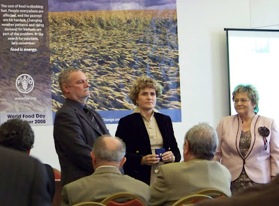

Wednesday, October 15, 2008
Monday, October 13, 2008
28th World Food Day
"Let's remember: food is energy"
World Food Day
World Food Security -
the Challenges of Climate Change and Bioenergy.
Venue: Hungarian Agricultural Museum
Date: 16 October 2008
Organised jointly by the Regional Office for Europe and Central Asia, the Ministry of Agriculture and Rural Development, as well as the Hungarian Scientific Association of Food Industry and the Hungarian Association of Agricultural Science the event will take place in the Vajdahunyad Castle in the City Park of Budapest. Chaired by Dr. Miklós Süth, State Secretary of MoARD, the agenda will discuss the topic "World Food Security - Challenges of the Climate Change and Bioenergy".A presentation will be delivered discussing the theme from the Hungarian perspective by Secretary General of the Hungarian Academy of Science, whereas the global outlook will be provided by Mrs. Maria Kadlecikova, Regional Representative of FAO for Europe and Central Asia.
Note: FAO is among the leading UN organisations which apply geospatial information on operational basis. FAO promotes user friendly solutions e.g. opensource softwares, standard based approach and alternative e.g. for the GEOSS portal.
Actually, according to the selected topics, this event also an important contribution to the International Year of the Planet Earth.
Monday, October 06, 2008
Report to GSDI President on the WGISS-26 completed
 The 18 page report reflects the rich professional content of the intensive meeting of the leading space agencies and some national academy of sciences in the field of Earth Observation information systems and services hosted by NOAA in Boulder one week ago. The report summarizes the joint meeting of WGISS and the Committee on Architecture and Data of GEO the Group of Earth Observation Systems of System arranged by IEEE as well.
 Photo portfolio:
http://picasaweb.google.com/gabor.remetey
Saturday, October 04, 2008
GISTDA's Thai Earth Observation Satellite in orbit

THEO in orbit
1st October 2008
For details, please visit the official website at http://www.gistda.or.th/Gistda/THEOS_launch1en.html
The website has downladable documents and useful reference links as press releases:
THEOS User Handbook (English - pdf)
THEOS User Handbook (e-book)
- Successful launch of THEOS (EADS Astrium 01/ 10/ 2008)
- Russia launches Thai satellite on converted missile (15:44 | 01/ 10/ 2008)
http://en.rian.ru/russia/20081001/117363703.html
- THEOS in orbit; set to transmit Bangkok photos (MCOT.net 01/ 10/ 2008)
- After lengthy delay, rocket finally allowed to launch (by Stephen CLARK, SPACEFLIGHT NOW 01/ 10/ 2008)
- Earth Observation (Bangkok Post 01/ 10/ 2008)
- THEOS Satellite (Wikipedia)
- Russia to launch Thai satellite on Wednesday October 1, 2008
http://spacefellowship.com/News/?p=6819
- Russia to launch Thai satellite on Wednesday (news 30/09/2008/21:48 )
http://en.rian.ru/russia/20080930/117343796.html
Hungarian Company GiziMap at the Frankfurt Book Fair

From our daily mail:
"Dear Gabor,
We would like to inform you that GiziMap takes a part in Frankfurt Book Fair (October 15-19), Hall 3.1. K 677. You are welcome on our stand. Please write us if you would like to fix an appointment. Please find in attachment list of GiziMap titles.
Best regards
Gizella Bassa"
GiziMap Map Design & Publishing
Tel/fax: +36 1 326 07 17, e-mail: gizimap.mant@mtesz.hu
Portfolio of GIZIMAPWe would like to inform you that GiziMap takes a part in Frankfurt Book Fair (October 15-19), Hall 3.1. K 677. You are welcome on our stand. Please write us if you would like to fix an appointment. Please find in attachment list of GiziMap titles.
Best regards
Gizella Bassa"
GiziMap Map Design & Publishing
Tel/fax: +36 1 326 07 17, e-mail: gizimap.mant@mtesz.hu
Maps Scale Size, cm
AFGHANISTAN Geo. Oxford Cart.-GiziMap 1:3 000 000 ISBN 978 963 00 8316 4 > ISBN-13 66×70
ALGERIA Geographical 1:2 500 000 ISBN 978 963 86808 1 5 > ISBN-13 99×88
ALGERIA Road Map 1:2 500 000 ISBN 963 87030 0 8 99×88
BAGHDAD City Map 1:25 000 ISBN 963 206 285 X 73×68
BEOGRAD Street Map 1:20 000 ISBN 963 00 5942 8 68×92
CAUCASUS Geographical 1:1 000 000 ISBN 978 963 00 6581 8 > ISBN-13 117×83
CAUCASUS Road Map 1:1 000 000 ISBN 963 02 9668 3 CM 117×83
CENTRAL ASIA Geographical 1:1 750 000 ISBN 978 963 03 7238 1 > ISBN-13 122×82
CENTRAL ASIA Road Map 1:1 750 000 ISBN 963 03 7239 8 CM 122×82
CHINA Geographical 1:4 750 000 ISBN 978 963 87465 1 1 > ISBN-13 122×88
CHINA Reference Map (Political) 1:6 500 000 ISBN 963 86808 6 5 CM 96×68
CHINA South (1) Geographical 1:2 000 000 ISBN 978 963 87030 3 3 > ISBN-13 125×88
CHINA Central (2) Geographical 1:2 000 000 ISBN 978 963 87030 4 0 > ISBN-13 125×88
CHINA Northeast (3) Geographical 1:2 000 000 ISBN 978 963 87030 5 7 > ISBN-13 97×88
CHINA Northwest (4) Geographical 1:2 000 000 ISBN 978 963 00 8051 4 > ISBN-13 99×88
CUBA Geographical NEW Dec 1. 2008 1:1 000 000 ISBN 978 963 87465 6 6 > ISBN-13 122×64
DALMATIA * ISTRIA Geogr. New Edition 1:250 000 ISBN 978 963 216 314 7 > ISBN-13 125×88
DALMATIA * ISTRIA Road Map 1:250 000 ISBN 963 86808 5 7 CM 125×88
EGYPT Geographical 1:1 300 000 ISBN 978 963 87030 8 8 > ISBN-13 100×88
ESTONIA Road Map 1:400 000 ISBN 963 450 043 9 CM 97×67
INDIA Geographical 1:3 000 000 ISBN 978 963 212 163 5 > ISBN-13 86×125
INDIA Road Map 1:3 000 000 ISBN 963 86808 7 3 CM 86×125
IRAN Geographical 1:2 000 000 ISBN 978 963 87030 2 6 > ISBN-13 98×88
IRAQ Geographical New Edition 1:1 750 000 ISBN 978 963 204 299 2 > ISBN-13 73×68
KAZAKHSTAN Geographical 1:3 000 000 ISBN 978 963 00 8315 7 > ISBN-13 120×88
KAZAKHSTAN Political 1:3 000 000 ISBN 963 00 8050 8 CM 120×88
KOSOVO Geographical 1:250 000 ISBN 978 963 00 3920 8 > ISBN-13 99×69
LATVIA Road Map MapLink - GiziMap 1:400 000 ISBN 963 02 9669 1 CM 117×83
LIBYA Geographical 1:1 750 000 ISBN 963 86808 0 6 CM 98×88
LIBYA Road Map 1:1 750 000 ISBN 963 217 610 3 CM 98×88
MACEDONIA Road Map 1:250 000 ISBN 963 02 9667 5 CM 89×69
MAURITANIA Geographical NEW 1:1 750 000 ISBN 978 963 87465 5 9 > ISBN-13 94×88
MIDDLE EAST Political NEW Dec 1. 2008 1:4 000 000 ISBN 978 963 87465 7 3 > ISBN-13 125×88
MONGOLIA Geographical 1:2 000 000 ISBN 978 963 86808 2 2 > ISBN-13 124×83
MONGOLIA Road Map 1:2 000 000 ISBN 978 963 86808 8 4 > ISBN-13 124×69
MONTENEGRO Geographical 1:250 000 ISBN 978 963 00 5482 9 > ISBN-13 68×93
MOROCCO Geographical 1:1 250 000 ISBN 978 963 87465 0 4 > ISBN-13 99x88
NEW ZEALAND Geographical 1:1 700 000 ISBN 978 963 87030 9 5 > ISBN-13 74x94
OMAN * UAE Geographical 1:1 250 000 ISBN 978 963 87030 7 1 > ISBN-13 74×94
SAUDI ARABIA Geographical NEW 1:3 000 000 ISBN 978 963 87465 2 8 > ISBN-13 100×88
SERBIA*KOSOVO*MONTENEGRO Road M. New Ed. 1:500 000 ISBN 978 963 00 8053 8 > ISBN-13 81×118
SILK ROAD COUNTRIES Geo. New Edition 1:3 000 000 ISBN 978 963 204 138 4 > ISBN-13 125×88
SILK ROAD COUNTRIES Political 1:3 000 000 ISBN 978 963 204 137 7 > ISBN-13 125×88
ST LUCIA Road Map NEW 1:50 000 ISBN 978 963 87465 4 2 > ISBN-13 69×94
TIBET Geographical 1:2 000 000 ISBN 978 963 204 139 1 > ISBN-13 124×84
TIBET Road Map 1:2 000 000 ISBN 978 963 00 8052 1 > ISBN-13 124×84
TRANSYLVANIA South-Eastern 1:200 000 ISBN 963 86808 9 X 82×118
UKRAINE * MOLDOVA Road Map 1:1 200 000 ISBN 978 963 450 044 5 > ISBN-13 116×82
ZÜRICH Street Map 1:12 500 ISBN 963 86808 3 0 CM 75×94
Geographical = The relief is with elevation tints Road Map = The relief is with hillshading
October 2008
HUCO registered with poster to UNGIWG-9 Meeting
UNSDI HUCO and its environment is the title of the proposed poster intended for the interactive poster exhibition of the 9th Meeting of United Nations Geographic Information Working Group hosted by COPUOS in Vienna, Austria. The open part of the event will take place on November 6-7, 2008. The representaton of HUCO by its coordinator (Secretary General of HUNAGI) was seconded by the Director General of FÖMI, dr. Szabolcs Mihály. FÖMI is for the Institute of Geodesy, Cartography and Remote Sensing, flagship of the Hungarian GI institutions, a core stakeholder of the UN Spatial Data Infrastructure Hungarian Coordination Office established in September 2006. HUCO was invited on behalf of the Co-Chairs of UNGIWG by the Director of the Geneva based UNGIWG Secretariat. Registration was made on-line on 3rd October 2008.
Friday, October 03, 2008
HUCO site attracts worldwide visitors
Geographical distribution of HUCO site visitors on a single day of October 3, 2008

New GSDI Regional Newsletters released
The SDI Regional Newsletters for October 2008 are now posted on the GSDI home page at http://www.gsdi.org
You may also download them directly as follows:
SDI-Latin America and Caribbean Newsletter
http://www.gsdi.org/newsletters/SDILACv5n10Espanol.pdf (Spanish)
http://www.gsdi.org/newsletters/SDILACv5n10English.pdf (English)
Portuguese translations of the newsletter are posted as they arrive and may be downloaded at http://gsdi.org/newsletters.asp
SDI-Africa Newsletter
http://www.gsdi.org/newsletters/SDIAfricav7n10.pdf (English)
SDI-Asia Pacific Newsletter
http://www.gsdi.org/newsletters/SDIAPv5n10.pdf (English)
Chinese translations of the newsletter are posted as they arrive and may be downloaded at http://gsdi.org/newsletters.asp
Past and current SDI Regional newsletters are also accessible in the archives at http://www.gsdi.org/newsletters.asp Also posted here are the SALB Newsletter and EIS-Africa Newsletter.
Please forward the newsletters to others that may be interested.
ANNOUNCEMENTS DURING THE MONTH
If you want to be kept up to date on announcements in your region of the world throughout the month or want to contribute announcements to others in your region, subscribe to the appropriate SDI discussion lists at
http://www.gsdi.org/discussionlists.asp Among the several discussion list offerings include:
SDI-Africa Discussion List
http://lists.gsdi.org/mailman/listinfo/sdi-africa
SDI-AP (Asia-Pacific) Discussion List
http://lists.gsdi.org/mailman/listinfo/sdi-asiapacific
SDI-LAC (Latin America and Caribbean) Discussion List
http://lists.gsdi.org/mailman/listinfo/sdi-latinamericacaribbean
--
****************************
If you would like to sign up for the GSDI News List,
please visit http://www.gsdi.org/
UNSDI HUCO Stakeholder & HUNAGI member Corvinus University at the ISDE Summit in Potsdam
Preliminary program ISDE Summit
Source: www.isde-summit-2008.org
"Wednesday, 12. November
8.30 Registration
9.30 -10.30 Introduction to the Summit and Welcome Addresses
M. Ehlers (GfGI, Summit Director)
R. F. Hüttl (GFZ Potsdam, Summit Co-Director)
H. Guo (ISDE, secretary general)
N.N. (State Representative, Brandenburg)
10.30 – 11.00 Coffee Break
Keynote Session (coordinated by desert.net):
Desertification: the Role of Policy, Geoinformation, Earth Observation and Modelling
11.00 – 13.00
N.N. (tbd)
G. del Barrio (Estacion Experimental de Zonas Aridas, Spanish National Research Council
CSIC, Almeria, Spain) “Assessment and monitoring of desertification: a geomatic approach”
M. Mulligan (King’s College London, Department of Geography, UK) “Geobrowser based
simulation models for land degradation policy support”
J. Hill (Remote Sensing Department, University of Trier, Germany) “Dryland degradation and
desertification: satellite-based assessment and monitoring concepts for a global problem”
13.00 – 14.00 Lunch Break
Global Change
14.00 – 14.45 Keynote M. Latif (Maritime Meteorology, IFM-Geomar, University of Kiel,
Germany) “The climate of the 20th and 21st century”
14.45 – 15.30 Keynote D. Stammer (Center for Marine and Climate Research, University of
Hamburg, Germany “Ocean reanalyses: status and their use for improving climate forecast.”
15.30 – 16.30
V.F. Krapivin; F.A. Mkrtchyan
(Institute of Radioengineering and Electronics, Russian Academy of Sciences, Moscow,
Russia): „An adaptive remote sensing technology fort the nature-society system
biocomplexity assessment”
P.A. Propastin (Department of Geography, Georg-August-University Göttingen, Germany;
Laboratory of Remote Sensing and Image Analysis, Kazakh Academy of Science, Almaty,
Kazakhstan); M. Kappas (Laboratory of Remote Sensing and Image Analysis, Kazakh
Academy of Science, Almaty, Kazakhstan): “Linkages between the current climate change,
the political change in Kazakhstan and trends in the photosynthetic activity of vegetation”
W. Wan (State Key Laboratory of Remote Sensing Science, Institute of Remote Sensing
Applications, Chinese Academy of Sciences; Graduate School of the Chinese Academy of
Sciences, Beijing, China) ; Y. Xue (State Key Laboratory of Remote Sensing Science,
Institute of Remote Sensing Applications, Chinese Academy of Sciences. Beijing, China;
Department of Computing, London Metropolitan University, London. UK); Y. Wang; Y. Li; J.
Guang; J. Ai; L. Bai (State Key Laboratory of Remote Sensing Science, Institute of Remote
Sensing Applications, Chinese Academy of Sciences; Graduate School of the Chinese
Academy of Sciences, Beijing, China): “High Performance Geocomputation for Digital Earth
– A Case Study of Aerosol Retrieval from Remotely Sensed Data”
H.M. Füssel (Potsdam Institute for Climate Impact Research, Germany): “Climate, geography and macroeconomics: A reanalysis of the G-Econ database“
Earth Observation and Modelling
16.30 - 17.15 Keynote S. Schubert (Global Modeling & Assimilation Office, NASA/Goddard
Space Flight Center, Greenbelt, MD, USA) “NASA's Modern Era Retrospective-Analysis for
Research and Applications (MERRA): Early Results and Future Directions”
17.15 – 18.15
Salihou; Y. Loya (ISIG - Institut Supérieur d`Informatique et de Gestion Ouagadougou,
Burkina Faso); B. Somé; L. Somé (LANIBIO – Université de Ouagadougou, Burkino Faso);
M. Daniel; J.Sequeira (LSIS - ESIL, Université de la Méditerranée, Marseille, France):
“Remote Sensing and modeling contribution to ecosystem control in Burkina Faso”
T. Peisker; D. Spengler; K.Segl; S. Itzerott; H. Kaufmann (GeoForschungsZentrum
Potsdam, Germany): „Artificial 3D crop field for the simulation of hyperspectral reflectance
data”
E. Forootan, M.A, Sharifi (Surveying and Geomatics Engineering Department, Faculty of
Engineering, University of Teheran, Iran): “Multi-Sensor Analysis of the Lake Victoria Basin
Variations”
C. Stasch, A. C. Walkowski (Institute for Geoinformatics, University of Münster, Germany):
“A Geosensor Network Architecture for Disaster Management based on Open Standards”
18.15 – 22.00 Postersession & Icebreaker Party
Thursday, 13. November
Simulation and Modelling
8.30 - 9.15 Keynote M. Goodchild (National Center for Geographic Information and
Analysis, University of California, Santa Barbara, CA, USA) “Simulation, modelling and digital
earth: status and prospects”
9.15 - 10.15
T. Blaschke; M. Biberacher; S. Gadocha; D. Zocher; M. Mittlböck; E. Hauslauer; I.
Schardinger (Research Studio iSPACE, Salzburg, Austria); J.Strobl (Z_GIS, Centre for
Geoinformatics, University of Salzburg, Austria): “Virtual Power Plants: spatial energy
models in times of climate change”
V.F. Krapivin; F.A. Mkrtchyan (Institute of Radioengineering and Rlectronics, Russian
Academy of Sciences, Moscow, Russia): „GIMS - Technology for the operative
environmental diagnostics”
E. Ivits; M. Cherlet, G. Buchanan (DG JRC, Italy), D. Chamberlain (BTO, England):
„Remote sensing derived phenological indicators to explain European farmland bird
distribution pattern”
R. J. Corner (Co-operative Research Centre for Spatial Information, Australia); M. Marinelli
(Curtin University of Technology, Bentley, Australia): “Modelling the effects of data
uncertainty on agricultural and environmental models under global change conditions”
10.15 – 10.45 Coffee Break
Earth observation
10.45 - 11.30 Keynote H. Guo (Center for Earth Observation and Digital Earth, Chinese
Academy of Sciences) “ABCC Program: Global Change Study Using Space Technology”
11.30 – 13.00
A, Roff (Co-operative Research Centre for Spatial Information, University of New South
Wales, Sydney, Australia); D. Silverstone (NSW Department of Environment and Climate
Change, Parramatta , Australia) G. R. Taylor; M. Day; A. L. Mitchell (Co-operative
Research Centre for Spatial Information, University of New South Wales, Sydney, Australia);:
“Beyond land-cover mapping: Semi-automated delineation of vegetation pattern using
segmentation”
C. Aubrecht; M. Köstl; K. Steinnocher (Austrian Research Centers GmbH, Vienna,
Austria): “Functional object grouping – An advanced method for integrated spatial and space
related data mining”
D. Tiede (Centre for Geoinformatics (Z_GIS), University of Salzburg, Austria); S. Lang
(Centre for Geoinformatics (Z_GIS), University of Salzburg, Austria; Institute of Landscape
Architecture and Environmental Planning, Berlin): “Rapid dwelling extraction from VHSR
satellite imagery in refugee camps and dissemination of conditioned information via virtual
globes”
P. Milenov; D. Kapnias; W. Devos (European Commission, Joint Research Centre,
Agriculture Unit, GeoCAP team): “Best Practice and Quality Checking of Ortho Imagery –
toward a common approach”
T. Soukup (GISAT, Prague, Czech Republic); Y. Bushuyev (Dniprocosmos State Company,
Dniepropetrovsk, Ukraine); M. Popov (Scientific Centre for Aerospace Research of the
Earth, Kiev, Ukraine); A. Tarariko (Institute of Agroecology of the Ukrainian Academy of
Agrarian Sciences, Kiev, Ukraine);V. Starovoitov (United Institute of Informatics Problem of
the Belarus Academy of Sciences, Minsk Belorussia); K. McCloy (Faculty of Agricultural
Sciences, University of Aarhus, Denmark): “Technology of automated land cover
classification based on the remote sensing data”
S.Hese; C. Schmullius (Department of Earth Observation, Institute of Geography, Friedrich-
Schiller-University, Jena, Germany): “Strategies for object-oriented thermokarst lake change
analysis in Siberia using very high resolution multitemporal satellite data”
13.00 -14.00 Lunch Break
Spatial Data infrastructure
14.00 - 14.45 Keynote A. Annoni (Spatial Data Infrastructures Unit, Institute for
Environment and Sustainability , European Commission Joint Research Centre, Ispra, Italy)
“Regional and Global spatial data infrastructures: a key to assess and monitor
environmental changes”
14.45 - 15.45
C. Graul; A. Zipf (University of Bonn, Germany): “Putting Biogeographic Research on the
Spatial Web: Towards Interoperable Analysis Tools for Global Change Based on the Web
Processing Service (WPS)”
U. Boes (URSIT Ltd., Sofia, Bulgaria); R. Pavlova (Technical University Sofia, Bulgaria):
”Spatial Data Infrastructures by 2020 – where do they go?”
D. Doktor (Imperial College, Department of Biology, UK); F. W. Badeck (Helmholtz-Centre
for Environmental Research - UFZ, Leipzig, Germany); A. Bondeau (Potsdam Institute for
Climate Impact Research, Potsdam, Germany); D. Koslowsky (Free University of Berlin,
Department of Meteorology, Berlin, Germany): “On the comparison of point and area-wide
observations of vegetation”
E. Gennai (ESRI Europe): ”Spatial Data Infrastructures, building as one”
15.45 – 16.15 Coffee Break
Visualisation
16.15 – 17.00
D. Wortley (Serious Games Institute, Coventry University, UK): “Integrating Physical and
Virtual Worlds for Sustainable Development”
F. Hruby; J. Kristen; A. Riedl (Department of Geography and Regional Research,
Cartography and Geoinformation (IfGR), University of Vienna, Austria): “Global Stories on
Tactile Hyperglobes – visualizing Global Change Research for Global Change Actors”
P. Paar (Lenné3D LLC. Berlin); K. Appleton (School of Environmental Sciences, University
of East Anglia, Norwich); M. Clasen (Zuse Institute Berlin, Dept. of Visualization and Data
Analysis); M.Gensel (Zuse Institute Berlin, Dept. of Visualization and Data Analysis); S.
Jude (Tyndall Centre for Climate Change Research, University of East Anglia, Norwich); A.
Lovett (School of Environmental Sciences, University of East Anglia, Norwich):
“Interactive Visual Simulation of Coastal Landscape Change”
18.00 Program Sanssouci Castle
19.00 Social Evening Event (Dinner) & Poster Awards
Friday, 14. November
Simulation and Modelling
9.00 - 09.45
Keynote Deren Li (State Key Laboratory of Information Engineering in Surveying, Mapping
and Remote Sensing): “Role of Geospatial Technology in Wenchuan Earthquake”
9.45 -11.00
J. LeLievre (Department of Sustainability and Environment, Melbourne, Australia); A. Kealy
(Department of Geomatics, University of Melbourne, Parkville, Australia): “Homogenous
positioning using CORS networks in a Digital Earth“
N. de Lange; C. Plass (Institute for Geoinformatics and Remote Sensing, University of
Osnabrueck, Germany): “WebGIS with Google Earth and Google Maps“
T. Häring; V. Hochschild (Department of Geography, University of Tübingen, Germany); M.
de Paly; C. Henneges (Department of Informatics, University of Tübingen, Germany):
“Modelling Tsunami Vulnerability – The development of a Tsunami Inundation Model with
Machine Learning tools“
D. Lincke; C. Ionescu; N. Botta (Potsdam Institute for Climate Impact Research, Germany):
“A generic library for earth system modelling based on monadic systems“
K. Frotscher; C. Hütting (Institute for Geography, Friedrich-Schiller-University Jena): “The
monitoring potential of Terra/Aqua-MODIS data in boreal forests”
11.00 - 11.15 Coffee Break
11.15 -11.45 Three best poster presentations
Urbanisation
11.45 – 12.45
O. Grübner; B. Jakimow; K. Janson; T. Lakes; P. Hostert (Humboldt University,
Department of Geography, Berlin, Germany): “Linking ecological, economic, and social data
in a health data model to analyse complex dynamics in informal settlements in Dhaka,
Bangladesh“
G. Zeug; S. Eckert (Joint Research Centre of the European Commission, Institute for the
Protection and Security of the Citizen, Support to External Security Unit, Ispra, Italy) T.
Kukuk; U.,Steiner (GAF AG, Munich, Germany); D. Ehrlich (Joint Research Centre of the
European Commission, Institute for the Protection and Security of the Citizen, Support to
External Security Unit, Ispra, Italy): “Monitoring urban city growth and its impact on the
environment: the case study of Sana’a, Yemen”
TBD.
M. Moeller (Austrian Academy of Science, GIScience, Salzburg, Austria; University of
Bamberg, Institute of Geography, Bamberg, Germany): “Metropolitan Growth Mapped from
Space Images”
12.45 - 13.00 Break
Urbanisation & Visualisation
13.00 -14.00
T. Nocke; T. Sterzel (Potsdam Institute for Climate Impact Research (PIK)); M. Böttinger
(German Climate Computing Centre (DKRZ); M. Wrobel (Potsdam Institute for Climate
Impact Research (PIK)): “Visualization of Climate and Climate Change Data: An Overview”
J.-P. Aurambout; C. Pettit; H. Lewis (Department of Primary Industries, Victoria, Australia):
“Digital Globes: gates to the digital earth”
J. Schiewe; A. Krek; I. Peters; H. Sternberg; K.-P. Traub (Hafen City University Hamburg,
Germany): „Developing and evaluating tools for Urban Research”
”T. Lakes (Humboldt University Berlin, Department of Geography); S. Lautenbach
(Humboldt University Berlin, Department of Geography; Helmholtz-Zentrum für
Umweltforschung GmbH ): “Modelling urban land use systems under transition – from
socialist to postsocialist dynamics in urban areas”
14.00 -14.45 Lunch Break
14.45 – 16.45 Resumee & Panel Discussion
Software presentations:
Simon D. Hennig; D. Hoffmeister; U. Baaser; G. Bareth (Dept. of Geography, University of
Cologne): ”CampusGIS 3D”
W. H. Mayer (PROGIS Software GmbH, Villach, Austria): “Planning and valuation of
ecological performances with the holistic and integrated agro-environment software-
technology AGROffice”
Poster Presentations:
C. Chen (College of earth sciences, Daqing Petroluem Institute, China); L. Weifeng (Sinopec
Exploration & Production Research Institute, Beijing, China): “New Computer Graphics Technologies
for Digital Earth Visualization”
D. Vassilaki; C. Ioannidis (School of Rural and Surveying Engineering; National Technical University of
Athens); A. Stamos (School of Civil Engineering, National Technical University of Athens): “Geospatial
Data Integration using Automatic Global Matching of Free-Form Curves”
Z. Dingiu; F. Jianping (Institute of Computing Technology; Shenzen Institute of Advanced Technology;
Chinese Academy of Sciences): “PSDC: Parallel Simulation of Digital City”
M. Gaál (Corvinus University of Budapest): “Expected changes in climatic conditions of maize growing
– Hungarian case study”
G. Schaab; P. Dammann; F. N. Muchori; N. Ojha; H. Zimmer (Faculty of Geomatics, Karlsruhe
University of Applied Sciences); „Biodiversity monitoring and forest management involving geospatial
data in Kakamega Forest (Kenya): Tools tailored to the users’ needs.”
H. Jiang; Q. Wang; X. Wang (Key Laboratory of Spatial Data Mining & Information Sharing of
Ministry of Education, Fuzhou University; Spatial Information Research Center of Fujian
Province, Fuzhou University, Fujian, China): “Simulation and Spatial-Temporal Analysis of forest
net primary productivity in Fujian Province”
Y. Jiang; S. Bi ((Key Laboratory of Remote Sensing Information Sciences, Institute of Remote Sensing
Application, Chinese Academy of Sciences, Beijing, China): “Dynamic Object-oriented Model and the
applications for the Digital Earth”
Neumann, C. (University of Potsdam) : “Linkage of climate variables from AVHRR raster data to the
heterogeneous layout of sub-catchments in the Ebro Basin”
J. Lian (Key Lab of 3D Information Acquisition and Application, MOE, School of Resource and
Environmental Science, Capital Normal University, Beijing, China); X. Li (Key Lab of Resources
Environment and GIS, Beijing, China):
“Research and Development of GIS Project Based on XML”
A. Tarariko (Institute of Agroecology of the Ukrainian Academy of Agrarian Sciences, Kiev, Ukraine);
A. Syrotenko (Institute of Agroecology of the Ukrainian Academy of Agrarian Sciences, Kiev, Ukraine);
V. Grekov”( Centre of Soil Fertility State Enterprise at the Ministry of Agrarian Policy of Ukraine, Kiev,
Ukraine): “Net of Agrarian Testing Polygons in System of Remote Monitoring of Agrarian Resources in Ukraine
L. Bolor-Erdenel (Mercy Corps, Gobi Forage project/Institute of Botany, Mongolian Academy of Sciences); J. Angerer (Dept of Ecosystem Science & Management, Texas A&M University, USA ); S.
Granville-Ross; M. Urgamal; D. Narangerel; D. Tsogoo; T. Stewart (Mercy Corps, Gobi Forage project/
Institute of Botany, Mongolian Academy of Sciences); D. Sheehy (Dept of Ecosystem Science &
Management, Texas A&M University, USA):
“Gobi Forage: An early warning system for livestock in the Gobi region of Mongolia”
S. Shumilov, J. Laubach; A. Rogmann (Department of Computer Science III, University of Bonn):
“GLOWA Volta GeoPortal - an active geodata repository and communication system”
M. A. Popov; S. A. Stankevich; A. I. Sakhatsky, A. A. Kozlova (Scientific Centre for Aerospace
Research of the Earth, Kiev, Ukraine): “Multispectral Imagery Normalized Difference Indexes for Land Cover Classification”
L. Siyuan; W. Gaojin; C. Wenjing; F. Shenzhong; F. Jianping (Shenzen Institute of Advanced
Technology, Chinese Academy of Sciences, Shenzen; Institute of Computing Technology,Chinese
Academy of Sciences, Beijing): “The Feasibility Analysis and Evaluation in Water TransferProject and Environment Change”
V. Starovoitov: (United Institute of Informatics Problems, Minsk, Belarus): “Multispectral image pre- processing for interactive satellite image classification”
G. Li; P. Lv; Y.Yunxuan (CEODE/CAS, Graduate School of CAS): “Research on parallel buffer
analysis based on Grided based HPC): ”Research on parallel buffer analysis based on Grided based HPC”
A. Sharifi; M.A. Rajabi (Department of Geomatics Engineering, University of Teheran); N. F.
Moghaddam (Department of Geosciensces, University of Shahid Beheshti, Teheran):
“Evaluation of Thermal Islands Logical Relation with Lineament Density Changes in Pre and Post- earthquake Satellite Images”
B. Hope; C. Kamrowski; (Department of Lands, NSW, Australia); D. Tien (Charles
Sturt University, NSW, Australia) “Refined Geo-referenced Image and Imagery Metadata Standards for SDI Implementation”
IYPE activities in Hungary
Dr. László Szarka, Secretary of the Hungarian National Committee (NC) of the International Year of the Planet Earth submitted the following formulation as contribution to an IYPE publication.
"The NC was established under the auspices of the Hungarian Academy of Sciences, the UNESCO and IUGS National Committees. The programs − organized by various associations, universities, research institutes and private companies − are under the High Patronage of the President of the Republic of Hungary. The National Launch Event was held on April 17, followed with a four-days long "Earth Science Fair" at the Hungarian Natural History Museum in Budapest. The IYPE was briefly reviewed in the Hungarian Parliament. The Hungarian Science Festival 2008, organized by the Hungarian Academy of Sciences has a special, IYPE-inspired slogan: "Science for the Habitable Earth". Between 3-7 November, 2008 tens of lectures are held at the Academy about the modern content of the Greek Classical Elements (Earth, Water, Air and Fire) and about the Humanity. IYPE NC for Hungary prepared a declaration (a Hungary-focussed “Paris Declaration”). In 2008 numerous publications (including the Hungarian version of the IYPE booklet series, under the title GEO-FIFIKA) are produced. Throughout the country symposia (among others a conference, pointing out the compatibility of Earth sciences and religion), contests, film shows (e.g., the movie “Another Planet”) and other performances are organized, with increasing media coverage."
Source: Secretariat of the Hungarian National Committee of the International Year of the Planet Earth.
For more information on the activities in Hungary please visit http://www.foldev.hu
UNSDI Stakeholder Meeting Report
Mr. T.Suha Ulgen wrote in his circular:
"Dear Colleagues,
Please find attached the UN Spatial Data Infrastructure (UNSDI) Stakeholder Meeting Reports held in Geneva on 20 June 2008 at the International Environment House. The reports reflect the discussions on the way forward to the implementation of a UNSDI , as proposed in the draft Interim UNSDI Framework Document (drafted after the February 2007 Rome UNGIWG meeting) and the governance structure (as proposed at the November 2008 Bangkok Plenary meeting).
As decided upon at the meeting, the Co-chairs and the Secretariat of UNGIWG will table a resolution/strategy for UNSDI at the 9th Plenary Meeting of UNGIWG in Vienna, Austria, in November 2008 for approval by UNGIWG Members to propose the following:
• The Draft UNSDI Framework Document should be read in conjunction with the UNSDI Strategy Document;
• UNGIWG continues to sponsor UNSDI;
• Approval of most members of UNGIWG is required to go ahead with the implementation of UNSDI;
• A lighter institutional structure with an UNSDI Board/Steering Committee, a Technical Advisory Group (TAG) and a Project Team governs UNSDI implementation; and
• An Memorandum of Understanding (MoU) formalizes UNSDI as a Project with commitment from Senior Management of sponsoring UNGIWG members.
Next steps include the revision of the Interim UNSDI Framework Document and the drafting of the UNSDI Project Governance Terms of Reference by late September for a next round of consultations in preparation for a vote at UNGIWG-9. The Co-chairs will also undertake further outreach with respect to building institutional understanding, including with various senior managers in the UN System, future Co-chairs, as well as the CEB Secretariat, the ICT Network, the office of ASG and the Chief Information Technology Officer.
Best regards,
For Alta Haggarty (OCHA) and Karl Steinacker (UNHCR),
T. Suha Ulgen (Mr.)
Coordinator - UN Geographic Information Working Group Secretariat (UNGIWG)
United Nations Office for the Coordination of Humanitarian Affairs (OCHA)
Geneva, Switzerland..."
The enclosures have been mailed by circular to the members of the UNSDI HUCO Stakeholders (Steering Committee members)
Friday, September 26, 2008
WGISS-26 will adjourn after a 8-hour Plenary today
UCAR building was the site of the WGISS-26 Meeting. Image: HUNAGI Visuals resource, 2008

Thursday, September 25, 2008
UNSDI HUCO invited to UNGIWG-9 in Vienna, Austria
UN at the Vienna International Center. Image: HUNAGI Visuals resource, 2004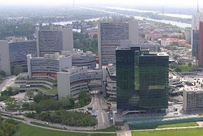
Coordinator of the UNSDI HUCO received invitation letter from UNGIWG Co-Chairs Ms. Alta Haggarty, Deputy Chief, Advocacy and Information Management Branch (AIMB) of UN Office for the Coordination of Humanitarian Affairs (OCHA) and Mr. Karl Steinacker of the United Nations High Commissioner for Refugees (UNHCR) to take part on the forthcoming UNGIWG-9 Plenary will be held in Vieanna Austria between 5-8, November 2008.
At UNGIWG-9 members will be called upon to elect new Co-chairs for 2009-10. It is expected that more then 30 UN agencies, departments, funds and local, national or regional partners are expected to attend UNGIWG-9.
Participants of the WGISS-26 today
 Participants of the WGISS-26 after the sessions devoted to the topics Virtual Constellation and SensorWeb
 Tuesday, September 23, 2008
GEO Joint Committee - CEO WGISS Meeting
CIRES of University of Colorado hosted the joint meeting . Images: HUNAGI Visuals resource, 2008
 . Images: HUNAGI Visuals resource, 2008
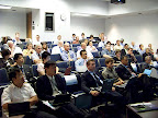 |
| From GEO COM WGISS |
Monday, September 22, 2008
UNSDI explicite mentioned in the GSDI talk delivered at the CEOS WGISS Meeting today
Colors of Green Center, venue of the WGISS 26 Meeting. Image: HUNAGI Visuals resource , 2008
 , 2008
Friday, September 19, 2008
WGISS Meeting 26 hosted by NOAA starts on 22 September in Boulder
GSDI represented at the 26th Meeting of the CEOS WGISS
The Atmospheric Research Center at Boulder will be also venue of the Joint Meeting of WGISS and GEO Committee on Architecture and Data.Tuesday, September 16, 2008
Videobroadcast of the GMES Forum 2008 from Lille - Click on and stay tuned!
Mr. Weissenberg of the European Commission delivering his presentation in the Opening Session 
GMES Forum 2008: Lille 16-17 September 2008

GMES Forum 2008: Lille 16-17 September 2008
Thursday, September 11, 2008
eSDI-Net Project Consortium Meeting started in Rome today
HUNAGI representative delivered an overview today on the Hungarian preparation, arrangements and follow-on actions related to the eSDI-Net+ Workshop held in Budapest on 29 August, 2008


Detailed tentative programme of the Light-Space-Image Conference is available
The tentative program of the event was just released by Bekes Ltd via dr. Attila A. Takács of MoEW and so far is available in Hungarian only at the HUNAGI Napló (http://hunagi8.blogspot.com)
Some of the active participants represents the following institutions, organisations:
ERDAS Inc.
Földmérési és Távérzékelési Intézet (FÖMI, Institute of Geodesy, Cartography and Remote Sensing)
Debreceni Egyetem (University of Debrecen)
MÁFI (Hungarian Geological Institute)
Szent István University
Insitute für Photogrammetrie und Fernerkundung, (TU-Vienna, Austria)
ELTE Geofizikai és Űrtudományi Tanszék (Dept of Geophysics and Space Science)
ELTE, Arcanum
Pannon University, Faculty Georgikon
Eötvös L. University of Sciences
Wednesday, September 10, 2008
Intergraph Annual User Conference 2008 in Hungary

HUNAGI member organisations Tekiré Ltd and graphIT Ltd arrange the 2008 Intergraph User Conference in Budapest at the Danubius Health Spa Resort in Margitsziget.
On-line registration: http://www.graphit.hu/Default.aspx?tabid=403
TeleAtlas Office Opening Event and Technical Show in Budapest

Mr.Norbert Hackner-Jaklin, TeleAtlas Sales Manager of the B2B in Vienna wrote in his letter:
"Dear Sir, dear Madam!
It is our pleasure to invite you to our Office Opening and technical demonstration of our Database Operations on the 24th of September 2008 at Rubin Wellness & Conference Hotel. Breaking news: the event will be postponed (RFG, Sept 18, 2008)
You will receive the latest news on Tele Atlas and its global activities like the exiting new perspectives driven by the integration of TomTom – MapShare data into our MultiNet database and we invite you to explore the world of our database operation department and to see how Tele Atlas captures and maintains its databases.
Please find the detailed agenda attached.
About Tele Atlas (only for prospects and press)
Tele Atlas delivers the digital maps and dynamic content that power many of the world’s most essential navigation and location-based services (LBS). Through a combination of its own products and partnerships, Tele Atlas offers map coverage of more than 200 countries and territories worldwide. The company was founded in 1984 and has approximately 2,000 full-time staff and contract cartographers at offices in 24 countries.
Today, Tele Atlas maps are developed with the insight of a community of millions of GPS system users worldwide, who are adding to the company’s unmatched network of sources to track and validate changes in real time, and deliver the best digital maps and dynamic content. For more information, visit www.teleatlas.com.
Tele Atlas is a subsidiary of TomTom N.V. "
Tuesday, September 09, 2008
FAO and FIG Comm7 Events in Verona
Verona. HUNAGI Visuals resource, 2004
International Seminar on State and Public Land Management
in Verona, Italy, 9-10 September 2008

International Seminar on State and Public Land Management
in Verona, Italy, 9-10 September 2008
Programme for Commission 7 Annual Meeting in Verona, 11-15 September 2008
More information using the www.fig.net website or via the FIG-Newsletters:
http://www.fig.net/pub/subscriptions/getnewsletter.htm.
More information using the www.fig.net website or via the FIG-Newsletters:
http://www.fig.net/pub/subscriptions/getnewsletter.htm.
Messrs. András Osskó (Budapest Land Office), Chair and Gyula Iván of FÖMI, Co-chair of the Comm 7 are participating the professional event.
eSDI-Netplus Project Consortium Meeting in Rome

The Meeting starts on 11th September at the La Sapienza University hosted by Prof. Mauro Salvemini, President of EUROGI.
Dr. Joachim Rix asked the Hungarian and Czech/Slovakian partners to submit information and share experiences based on the early eSDI-Net+ Workshop already done on 29 August in Budapest and scheduled for 10 September in Brno respectively. More information at www.esdinetplus.eu
Prominent visitors of the HUCO blog
Recent visitors of the HUCO blog during the past several hours includes universities, NASA and Japanese Governmental Authority.  Image: HUNAGI Visuals resource, 2008
Image: HUNAGI Visuals resource, 2008Sunday, September 07, 2008
Former students in surveying met 40 years after
Field exercise break in Sümeg in 1965. Left to right: Lajos Babós, Gábor Remetey-Fülöpp and László Niklasz.  The surveying students of the Budapest University of Technology graduated in 1968 met in Orfű, County Baranya yesterday. The host were Dr. László Aradi and László Bruhács of the Pollack Mihály Technical Faculty of the Pécs University of Sciences. Venue of the meeting was the University's Field excercise camp on the lakeside in Orfű. Besides the former students Academician Ákos Detrekői, Dr. Péter Riegler, Editor-in-Chief of the Geodézia és Kartográfia as well as Zoltán Uzsoki, Secretary General of the Hungarian Society of Surveying, Mapping and Remote Sensing and Manager of the Pécs Geodetic Shareholder Co. were present as invited guests. Four of the former students are closely involved in the development and use of the geoinformatics even today, namely dr. László Aradi Head of Department at the Pollack Faculty of Technology, dr. László Niklasz, chief of the GIS branch at graphIT Ltd, dr. László Csemniczky, President of the Hungarian Association of Geospatial Technology (MTE -gita Hungary) and dr. Gábor Remetey-Fülöpp, Secretary General of HUNAGI and head of the UNSDI HUCO. Some snapshots which were taken during the trip to Orfű will be available soon at http://picasaweb.google.com/gabor.remetey
The surveying students of the Budapest University of Technology graduated in 1968 met in Orfű, County Baranya yesterday. The host were Dr. László Aradi and László Bruhács of the Pollack Mihály Technical Faculty of the Pécs University of Sciences. Venue of the meeting was the University's Field excercise camp on the lakeside in Orfű. Besides the former students Academician Ákos Detrekői, Dr. Péter Riegler, Editor-in-Chief of the Geodézia és Kartográfia as well as Zoltán Uzsoki, Secretary General of the Hungarian Society of Surveying, Mapping and Remote Sensing and Manager of the Pécs Geodetic Shareholder Co. were present as invited guests. Four of the former students are closely involved in the development and use of the geoinformatics even today, namely dr. László Aradi Head of Department at the Pollack Faculty of Technology, dr. László Niklasz, chief of the GIS branch at graphIT Ltd, dr. László Csemniczky, President of the Hungarian Association of Geospatial Technology (MTE -gita Hungary) and dr. Gábor Remetey-Fülöpp, Secretary General of HUNAGI and head of the UNSDI HUCO. Some snapshots which were taken during the trip to Orfű will be available soon at http://picasaweb.google.com/gabor.remetey
Friday, September 05, 2008
Loss of documents may impact HUNAGI and UNSDI HUCO operation
Resources used for HUNAGI and UNSDI daily operation. Image: HUNAGI Visuals resource, 2008
Due to hard disk failure all stored data and documents since the last backup were lost on September 1, 2008. Recovery operation made by Macbolt was practically unsuccesful during the last several days. The impacts will be investigated asap. Archived documents from back-up drives, website and third-party servers will be downloaded to ensure the business as usual.
Due to hard disk failure all stored data and documents since the last backup were lost on September 1, 2008. Recovery operation made by Macbolt was practically unsuccesful during the last several days. The impacts will be investigated asap. Archived documents from back-up drives, website and third-party servers will be downloaded to ensure the business as usual.
Subscribe to:
Posts (Atom)